
Development of a Pilot Scale Water Resources Research Center Outputs and Products Data Portal
The primary goal for this proposed work is to develop an open data portal to archive and provide access to research products developed through efforts of UH WRRC and ASCCLG. The portal will improve the searchability for publications, reports, and data.
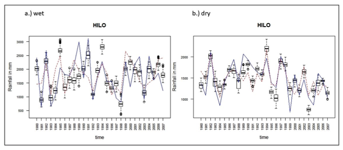
Evaluating Similarities and Differences Between Statistical and Dynamical Downscaling Projections
Activities in this project fall under four core objectives: (1) conduct place-based assessment of risk, vulnerabilities, and adaptation strategies; (2) support implementation of these strategies; (3) evaluate adaptation plans and policy throughout the region; and (4) integrate technical climate information and policy outcomes.
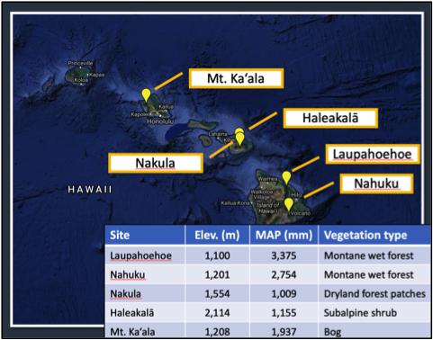
Cloud Water Interception in Hawai‘i
This study obtained data to develop a model to simulate the spatial patterns of cloud water interception (CWI) in Hawai‘i, sensors and canopy water balance systems were deployed at five sites. Three of the sites used tensiometers to estimate the spatial and temporal variability of recharge rates associated with CWI.

Development of Digital Meteorological Surfaces for Modeling of Hydrological Processes in Hawai‘i
This project is developing a system to automatically produce near-real-time climate map products, beginning with monthly and daily rainfall, at high spatial resolution.
Projecting Near-Term Climate Variability and Change of the Main Hawaiian Islands to Provide Actionable Climate Information to Resource Managers and Decision Makers
This study measures fog, wind, fog interception, changes in plant water use because of fog, and the amount of water added to the hydrological cycle by fog. The data is used to test a model to estimate cloud water interception (CWI) as a function of fog-water movement and vegetation type.

Identifying Groundwater Flow and Contamination to Streams: Kahaluu Watershed, Oahu
CRAIG R. GLENN
The surface waters in the Kahaluu Lagoon on the windward side of Oahu fronted by Kaneohe Bay have been shown to have very high levels of wastewater related bacteria.
The surface waters in the Kahaluu Lagoon on the windward side of Oahu fronted by Kaneohe Bay have been shown to have very high levels of wastewater related bacteria.

Demonstration Study of High-Rate Flotation/Contactor Treatment of Raw Wastewater
Research will be conducted in the following categories: biological wastewater treatment; innovative primary treatment for carbon diversion; thermal hydrolysis pre-treatment of sludges; anaerobic digestion; co-digestion of fats, oils, and grease (FOG); food waste; bioplastics; sludge dewatering; on-site wastewater treatment including passive denitrifying absorption systems and constructed wetlands; water recycling; membrane bioreactors; groundwater infiltration into sewers; stormwater runoff management including green roofs; and biofiltration systems.
RAM2 Modeling and the Determination of Sustainable Yields of Hawaii Basal Aquifers
Clark C.K. Liu
ABSTRACT: Basal aquifers, in which freshwater floats on top of saltwater, are the major freshwater supply for the Hawaiian Islands, as well as many other coastal regions around the world.
Modeling and Drainage Design for the Kaloi Gulch Watershed in Southern Oahu – Phase II
SPONSOR:R.M. Towill Corporation PROJECT PERIOD:05/27/08 – present ABSTRACT:Haseko (Ewa), Inc. proposed an 1,100-acre development at the lowermost reaches of the Kaloi Gulch watershed on Oahu, Hawai. According to the City’s storm drainage standard, the 100-year storm peak flow at the…
Experimental Study of Humidification-Dehumidification (HDH) Seawater Desalination Driven by Solar Energy
SPONSOR: USGS PROJECT PERIOD: 03/01/08 – 02/28/09 ABSTRACT: relatively new desalination process called humidification-dehumidification (HDH) was proposed as a feasible solution to the freshwater shortage problem in Hawaii. HDH operates under near ambient pressure and low temperature and can be…
![]()