
OFFICE: HOLMES HALL 283
PHONE: (808) 956-7848
E-MAIL: THOMAS@HAWAII.EDU
RELATED WEB PAGE: VIEW
EDUCATION:
- PhD, Geography, University of Hawaiʻi at Mānoa, 1983
- MA, Geography, University of Miami, 1977
- BS (cum laude), Geography and Mathematics, University of Miami, Florida, 1974
FIELDS OF INTEREST:
The foci of my research are (1) climate variability, both spatial and over time, including natural fluctuation and trends associated with global climate change, and looking at both past changes and projections of future changes; and (2) interaction between the atmosphere and the land surface, including effects of land cover change on exchanges of water, carbon, and energy over terrestrial ecosystems, effects of invasive plants on ecosystem function, and hydrological processes in tropical montane cloud forests.
Tom Giambelluca 2021–2022 Publications
RESEARCH PROJECTS
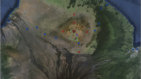
In this project we are planning and working to gain the acceptance and participation from relevant stakeholders for future deployment of instrumentation to continuously monitor the climate of the upper elevations of Mauna Kea

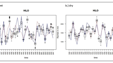
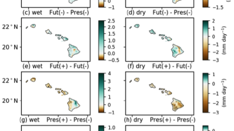
This research allows us to determine to what degree the apparent trends (mostly downward) in Hawai‘i rainfall can be attributed to the effects of global climate changes as opposed to natural variabilities. This outcome will be extremely valuable as a guide to interpreting projections of future changes.
Controlling or eradicating non-native plants in Hawai‘i is difficult and expensive. Knowledge of the impacts of non-native plants on water resources is important for water managers and conservation organizations to help them plan for the best use of their resources to restore and maintain the hydrological function of Hawai‘i’s watersheds.
The primary goal for this proposed work is to develop an open data portal to archive and provide access to research products developed through efforts of UH WRRC and ASCCLG. The portal will improve the searchability for publications, reports, and data.
Activities in this project fall under four core objectives: (1) conduct place-based assessment of risk, vulnerabilities, and adaptation strategies; (2) support implementation of these strategies; (3) evaluate adaptation plans and policy throughout the region; and (4) integrate technical climate information and policy outcomes.

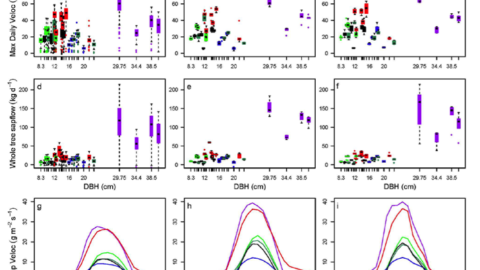
This study obtained data to develop a model to simulate the spatial patterns of cloud water interception (CWI) in Hawai‘i, sensors and canopy water balance systems were deployed at five sites. Three of the sites used tensiometers to estimate the spatial and temporal variability of recharge rates associated with CWI.
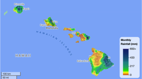
This project is developing a system to automatically produce near-real-time climate map products, beginning with monthly and daily rainfall, at high spatial resolution.
This study measures fog, wind, fog interception, changes in plant water use because of fog, and the amount of water added to the hydrological cycle by fog. The data is used to test a model to estimate cloud water interception (CWI) as a function of fog-water movement and vegetation type.
SPONSOR: National Institute for Water Resources, Water Resources Research Institute Program PROJECT PERIOD: 03/01/08 – 02/28/09 ABSTRACT: Water resources in Hawaii continue to experience increasing demand, putting pressure on existing sources and increasing the need for better estimates of resource…
SPONSOR: National Institute for Water Resources, Water Resources Research Institute Program PROJECT PERIOD: 03/01/2013-02/28/2014 ABSTRACT: The Hawaiian Islands have one of the most diverse rainfall patterns on Earth. The mountainous terrain, the persistent trade winds, the heating and cooling of…